Beach

Mission Beach

Cassowary

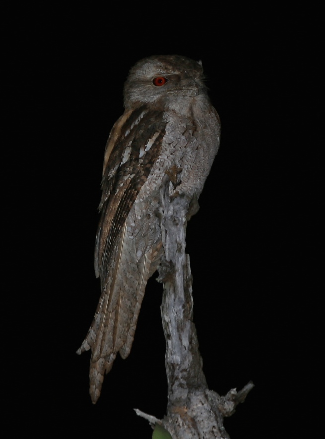
A Cassowary preens itself in the afternoon sunlight

Back to the coast we headed, taking a less precipitous road, descending 900m again towards Innisfail, then south to Mission Beach, driving past Djiru National Park before entering the quaint tourist village. The council operated caravan park sits behind the beach and offers powered sites for next to nothing so we settled in for a few days. We needed to get some schoolwork done with the kids, and the nearby library beckoned.

IMG_0137
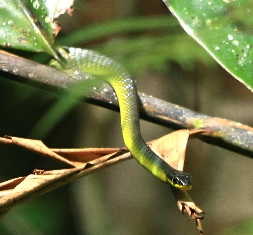
The National Park appeared to offer much better walking tracks than in Cape Tribulation so we set off initially on a short walk at Lacey Creek. The narrow path snakes through the thick forest, criss-crossing the creek and a few tell-tale cassowary droppings littered the track but none were spotted. I got mesmerised for 20 minutes watching a tree snake exploring the forest, systematically checking branches for food.

We walked the 3.2km Dreaming Trail, witnessed more cassowary droppings, oversized mounds of semi digested seeds, littering the path, but still no sightings. Many of the seeds were already germinating proving how effective the bird is as a jungle gardener.

With interest waning in the rain only Xavier and I continued from this track onto the 6km Musgravea track to Licuala. There was so much evidence of cassowaries that we were very optimistic about seeing one and sure enough 3km in a beautiful big specimen stood preening itself in the sunlight in the middle of the track. We carefully approached to about 20m, as these birds can be dangerous, particularly if protecting their chicks, but at this point it ducked into the undergrowth never to be seen again. A further 50m on and we encountered an echidna, an animal that we haven’t seen for ages.

This slideshow requires JavaScript.

Back at camp the kids were very excited to find a few very large and carefully compiled humpys on the beach, spending plenty of time hanging out in them with other kids. It was good for them to find lots of kids around their age that they could let some steam off with.

The adjacent park was lined with rather attractive palms with clumps of fruit of different colours hanging below the leaves and Amanda got particularly excited when she found out there were markets on whilst we were there. She returned with bags of local produce, including monster bananas a bargain at 14 for a dollar! Oscar scored himself a huge second hand tackle box for 4 dollars, Hannah headed for the pineapple slushie stall, and Xavier spent time at the gemstone stall. He later returned with his collection to show the man.

The laid-back feeling around Mission Beach was very appealing but the dreary weather that had commenced once we hit the rainforest, continued. The wind and rain prevented us from visiting nearby Dunk Island but it was still very relaxing and the kids completed a big chunk of work for school. The time to leave came too soon

Categories: 4WD, Adventure, Animal Action, australia, Australian Outback, Beach, Big Lap, Discover Australia, Explore Australia, Journey Narrative, Kids Travel, Natural World, Photography, Photos, Queensland, Road trip, Travel, Travel Adventure, Walks, Wildlife | Tags: , , , , , | Leave a comment

Elim Beach, Cooktown and beyond

As we left Lakefield National Park we were reaching for our phones to search Wikicamps for our next site. This App has proved invaluable on the trip, although many folks “secret” spots are now accessible to anyone with the App. One that looked good lies just north of Cooktown, on land owned by a sprightly 90 year old local named Eddy. Elim Beach is a fairly large site bordering the mangrove-lined beach, offering all basic amenities at a cheap price, and a short walk from Coloured Sands beach.

We met Eddy just outside his house making traditional style woomeras, or spear throwers. A bit deaf and not a man of many words but an interesting elder to talk to. He was disappointed that youngsters are no longer interested in the traditional ways and he seemed to be making as many woomeras as he could because no-one else will make them when he is gone. When quizzed about the properties of marine putty over original tree sap used as glue he shrugged gently dismissing the inferior quality with “white man’s glue”. He’s happy to use it though as his supply of traditional tree sap has dried up, again due to his fellow clan members rarely collecting it these days. The next morning we saw him leaving for town, dressed very smartly in jeans and long-sleeved shirt, probably one of the last of the “big men” in this region, and a great privilege to meet him.

Sandy, who we met the previous day, joined us at Elim Beach and joined us walking down to the coloured sands. We collected bags of different coloured sands, and Sandy painted the kids faces different colours yellows, oranges, and reds. There was even black sand.

The small art centre in nearby Hope Vale was worth a visit and showcased the local talent. We love the way indigenous artwork embraces natural products, and uses seeds either as “canvases” or for necklaces. On our way through Amanda had got talking to the local Lutherian pastor, the village still being very “church orientated”. When she couldn’t find a lemon in the grocery stall to go with Oscar’s Barra he sent us up the road to see his wife who donated one to the cause. The town of Hope Vale was a very friendly place that we should have spent more time in but we were on the move.

Cooktown was a short drive south from Elim Beach. It was windy, some say the windiest place in Australia but at least it was sunny too. We visited the museum to see the anchor and cannon from Captain Cook’s ship the Endeavour that were salvaged nearby where the ship had hit a reef just off the coast on 10th June 1770. All the ships heaviest items were thrown overboard to save the ship from sinking. Cook climbed a nearby mountain, where the lighthouse stands today, to observe the tricky situation he was in, with multiple reefs and unfavourable winds making further passage along the coast quite treacherous. We visited the spot but not being sailors couldn’t really contemplate his dilemma. The view was impressive though, and the reefs were still there too, scattered across the horizon! Back at the museum the kids performed a treasure hunt and I found it interesting to find European items that pre-date settlement, often by hundreds of years. Of particular interest were 15th century Chinese storage urns (probably brought by Chinese in the gold rush) and a rather ornate piece of Dutch porcelain from the 17th Century I believe, possibly even earlier. It had been acquired from the Jardine family who apparently had found it up near the tip of Cape York. History could have been written so differently!

Archer Point

Archer Point

Archer Point

Archer Point

South of Cooktown we had a couple of mandatory stops on the itinerary, the first being Archer Point. Recommended by a few travellers and Wikicamps, we stopped at a very windblown beach for lunch, the few caravans tucked behind palms for cover. The view was pleasant but the wind was thwarting even the bravest fishermen’s attempts to catch dinner.

Black Mountain National Park

Black Mountain National Park

We then headed inland through the Black Mountain National Park which are very aptly named. The range consists of massive black boulders of granite. With no soil very little grows there, and that which can survive has to endure temperature extremes as the rocks have terrific capacity to absorb solar heat. One large ancient tree high up appeared to have lost its battle to survive and a brown carcass sat perched high above us in the rock pile as we drove past.

Beyond here we stopped in to visit the Lion’s Den Hotel. Built in 1875 in Helenvale, next to the Little Annan River, this country pub is a well known tourist attraction, with all the expected associated paraphernalia. Large artworks cover the walls and any gaps on the wall have been covered in traveller’s graffiti, for a gold coin donation to the Royal Flying Doctor Service (RFDS). We left our Fifty Toes Walkabout mark, squeezing it in below the largest artwork in the room gladly contributing to the worthy cause of RFDS.

By late afternoon we arrived at Home Rule, in Rossville, a 100+ acre property, bordering national park, that hosts two large music festivals every year. Nestled in ancient rainforest next to a clear Wallaby Creek we were very surprised to see we were the only people there. The Wallaby Creek Festival is a festival of arts and music that runs for 3 days in late September every year, and considering some 500 people had been camping there only a week or so prior it was still in great condition with lush green lawns and only a few muddy patches. The rock festival hosts a larger crowd and lasts longer.

A 45 minute stroll through the forest took us to the Home Rule falls, actually within the adjacent National Park. A bracing swim was required and thirty toes braved the elements on a very overcast day, clambering over rocks that were as slippery as an ice rink. The tranquility was wonderful, only temporarily spoilt when I nearly trod on a rather large venomous red-bellied snake.

The quiet camp also gave us time to catch up on school work.

Categories: 4WD, Adventure, australia, Australian Outback, Beach, Big Lap, Discover Australia, Explore Australia, Journey Narrative, Kids Travel, Offroad, Photos, Queensland, Road trip, Travel, Travel Adventure | Tags: , , , , , , , | 2 Comments

Pennyfather and Mapoon, West of the Tip

This slideshow requires JavaScript.

And so the long journey back south begins in earnest. The drive back from Usher didn’t seem too bad with only one termite infested tree blocking our way, then the corrugations to the Jardine River ferry didn’t shake the bones like they did on the way up. Maybe we have finally got used to bull dust and corrugations now? It seems normal to drive to the left of the road markings, along the less corrugated but clearly worn paths of the locals.

On recommendations from travellers we had met on the Cape we were keen to explore a little of the Gulf side of the Cape. After 4 weeks on the Cape we were in need of supplies, particularly fresh fruit and vegetables, and curiosity was leading us to the city of Weipa anyway, so restocking and refueling was the order of the day.

Fruit Bat Falls

Fruit Bat Falls

A quick stop was required, firstly at Fruit Bat Falls to wash away excess bulldust, then at Bramwell station to view the “Rego tree”. then on to Moreton station for the night.

A “short cut” from the Old Telegraph Track south of Moreton took us across Batavia Downs station to York where we joined the Peninsula Developmental road leading to Weipa. With the exception of a few heavily corrugated sections this road soon improved and before we knew it we hit bitumen driving into Weipa.

Just north of Weipa lies the Pennyfather River, supposedly a top fishing spot, but also a beautifully peaceful beach camp.

Access is via a Rio Tinto mining lease and the only traffic lights we have seen for a while were those for mine vehicles passing. The boom-gate was broken so we watched quite a few monster trucks pass by, with loads of dusty bauxite piled high in the hold. Even the water trucks managed to dwarf our cars waiting patiently for the gates to rise. They follow behind spraying hundreds of litres of water on the road to reduce dust levels. In the end Simon jumped out of his car and physically lifted the boom-gate so all could pass.

Being on Aboriginal land a permit is required but once there a very long beach offers many camping options, from basic amenities for a small fee, managed by a ranger to free camping along the beach, south of the local beach shacks. We chose the latter, searching for a site that another family had told us had the makings of a funpark made from washed up debris from the beach. After ten minutes driving along the soft sand it was time to stop and we found a great shaded spot with a tyre swing. The Gulf waters lapped gently on the beach and the glassy water was a welcome change from the wind blown east coast. Thirty minutes later an onshore wind blew up and brought a veritable swell with it, shattering the initial idyllic appeal of this west coast.

It did improve the next day and we had fun trying unsuccessfully to catch massive trevally that were cruising up and down the shoreline. The fishing gods were not kind to us and once again sausages hit barbeque instead of fresh fish.

The kids built hammocks from fishing nets, strung between trees, and spent hours on the tyre swing.

Whilst we didn’t find a plaque, and there must be one there somewhere, the Pennfather River has historical significance as being the first place that a European landed in Australia. Willian Janszoon, a Dutch navigator, sailing in the Duyfken landed here in 1606, long before James Cook.

Today this area is totally alcohol-free and it is not permitted to even carry alcohol into this area, however, with no-one policing it, discarded bottles and cans litter the sand and bush where some people found it easier to discard rather than take the rubbish with them, thereby spoiling it for future visitors.

image

From Pennyfather we headed north for a couple of days to Mapoon where the Dulcie River meets the Gulf. The camp on the western ocean side offered more protection from the wind and on local advice Jackie Creek some 12km south along the beach offered good fishing opportunities

image

image

The kids together with Simon and Hilary’s girls scoured the shoreline for materials and commenced building a “humpy” city. Humpys are the temporary shelters that aborigines used, conical huts made from logs, with leaves or fur to cover the roof. The kids made scaled down versions from the long mangrove seeds that can be found everywhere, washed up with each tide.

Jackie Rivermouth

Jackie Rivermouth

Oscar and I slipped away for a quiet fish, driving down to Jackie Creek where we saw locals using spears to catch mud crabs amongst the reef. We had no success but witnessed plenty of “bait balls” of fish being doggedly pursued by larger fish around them and by a large flock of hungry terns diving wave after wave into the throng for a meal. The next day we returned at the right point of the tide and for a busy half hour caught mangrove jack for dinner, whilst keeping an eye out for a large crocodile we had seen when we arrived.

image

The wild horses called brumbies proliferate around Mapoon and Pennyfather too and it isn’t unusual, driving along the beach, to spot small groups or see their footprints coming to and from the beach and swamplands behind. We only saw the one crocodile and had a couple of shallow swims, then a local advised that they live in the swamplands behind the beach at this time of year, waiting for the big wet to arrive when they become more mobile and visible.

image

Shorebirds were present in abundance but with my ailing Canon EOS camera struggling to focus correctly, I couldn’t capture images

Categories: 4WD, Adventure, australia, Australian Outback, Beach, Big Lap, Camper Trailer, Discover Australia, Explore Australia, Journey Narrative, Kids Travel, Offroad, Photos, Queensland, Road trip, Travel, Travel Adventure | Tags: , , , , , , | 1 Comment

Cape York, the Tip (Part 2)

With the northern most compass point of the mainland behind us there was still plenty to do. We explored a 4WD track from the tip that crossed to Punsand Bay. A fairly tight and rugged track but not too difficult. The old telegraph terminated at a concrete bunker located just behind Cable Beach. Further on little side tracks around Roonba point took us to isolated beaches and mangrove forests, where corkscrew palms  spiralled their way towards the sky. Amanda stopped to investigate orchids growing amongst the tree branches, a few flowers starting to show.

Loo with a view

Loo with a view

One track led along a beach offering camp opportunities all over the place. We even stumbled, almost literally over what was arguably the best “Loo with a view”, a concrete construction, seat but no surrounding privacy. Just sit down and enjoy the view.

There are also a few historical remnants from WW2 in the area and to explore these we moved to Alau Beach as a new base to explore. Firstly we visited two plane wrecks, a DC3 bomber and a Bristol Beaufort, both having sufficient remnants to make them out. There are references to 3 other wrecks but without further information we couldn’t seek them. We drove down to Jacky Jacky creek on a increasing derelict track to a local camp that must be used for collecting mud crabs and mud clams amongst the mangroves.

Muttee Head WW2 radar tower

Muttee Head WW2 radar tower

Another road took us out to Muttee Head, and beyond to the mouth of the Jardine River. An old derelict and severely rusting radar tower stands forlornly in the forest, covered in vines, a stark reminder of the proximity of this part of Australia to action in the war.

Around the sleepy towns of Seisia and Bamaga it was impossible to miss the large numbers of horses wandering around untethered. Roaming along the roadsides, grazing through peoples gardens, some of them looking in very fine condition. Every now and then youngsters would trot past on their unsaddled steeds, all very adept in the art of horsemanship no matter what age.

We moved to Alau beach for a few days and Oscar and I took time out to fish from Seisia Jetty, once the weekly barge had been unloaded, reloaded, and departed. A large group of locals played in the water next to the jetty and a group of youngsters brought their horses for a swim to cool off in the searing heat of the midday sun.

The teenagers led their horses into the water, then stood on their backs and performed backflips into the water, in an effort to entertain the younger boys watching. Once cooled off they mounted the horses and cantered up the beach and back to the crowd swimming and frolicking behind us.

I felt a large tug on my line then suddenly the water surface erupted with a pirouetting shark, over 2m long. It performed this action 3 times, its entire body clearing the water each time, as it stripped line off my reel, then thankfully snapped it. A laconic comment from an elderly local fishing nearby suggested this was why no-one was catching anything. Another fishermen barked a call in local tongue to the crowd in the water and a mass exit, that any lifesaver would have been proud of, took place in seconds. Apparently crocodiles are not scary but big sharks are!

Palm Cockatoo

Palm Cockatoo

Frogmouth

Frogmouth

Back at our beach camp in Alau, the local trees acted as magnets for the birds and we were treated to Palm Cockatoos, yellow bellied sunbirds, frogmouths, kingfishers and many more.


Categories: 4WD, Adventure, australia, Australian Outback, Beach, Discover Australia, Explore Australia, Journey Narrative, Kids Travel, Natural World, Offroad, Photos, Queensland, Travel, Travel Adventure | Tags: , , , , , | 3 Comments

Cape York, The Tip (Part 1)

Firstly thanks to all the responses helping with my computer. It probably won’t be fixed until we get home which means blogging will be less frequent and probably fewer photos for a while.

After decamping from the beautifully tranquil Jardine River a short but very corrugated drive brought us to the ferry crossing where the 20m crossing costs you $129 and lasts barely a couple of minutes. It sounds expensive but is a return fare and does include the permit to enter the indigenous area as well as camping in designated areas around the tip of Cape York.

Bamaga is a sleepy township in the far north, offering a decent sized supermarket, post office, tavern, bakery and general store amongst others. A hasty re-fuel and restock and we headed 35km to the north easterly point of the Cape, to a campsite called Somerset. The Somerset Homestead is now in ruins, established in 1863 by John Jardine, farmed cattle, copra and had other commercial interests that included involvement in the pearling industry. Near to the campsite there are some old cannons, gravesites and some derelict ruins providing the inquisitive with a glimpse into the hardships of the past here. Fragments of old hand-blown black glass bottles can be found scattered in the bush, many dating back to the late 19th century.

Along the shoreline, behind the mangroves you can also find the remains of an old freshwater spring that was pooled as salvation for shipwrecked sailors, and graves of Japanese pearl divers.

Also along the shoreline, after negotiating crocodile infested mangroves and climbing the sharp rocks some remarkable indigenous art can be found in a cave, considerably pre-dating the homestead. Figures of fish, crocodiles and turtles, as well as other unidentifiable shapes were all clearly visible.

Some 900m away the large island of Albany offers fishing charter holidays, but has untouched beaches covered in turtle tracks with crystal clear water. The island also offered some protection from the prevailing onshore winds that greeted us all the way up the east coast of the Cape.

We explored the neighbouring coastline taking the five beaches track that weaves southwards through the bushland between beaches. We met another family with kids at SDEPS (whom we hadn’t seen for months) and took the photo at Fly Point of all the 8 kids. At the end of the track we found tracks that kept going and we explored at least two more beaches, the kids finding plenty of their new favourite shell, the chambered nautilus. Surprisingly there was less rubbish on the beaches here, probably because of the protection from Albany island.

Yellow-bellied sunbird

Yellow-bellied sunbird

The abundant and unique birdlife at the tip of the Cape York also provided an interesting diversion at dawn whilst everyone else was still waking up. The tally is now fast approaching 300 species on the trip and favourite birds have been changing regularly. Here the yellow-bellied sunbird was a welcome treat around the trailer.

This slideshow requires JavaScript.

The next day we had a challenge to meet, the third compass extremity of the mainland, Australia’s most northerly point. The dirt road wasn’t too bad, weaving at times through lush rainforest, before opening up at the beach. A short walk over the craggy headland past enormous rock cairns brought us to a very unimpressive simple sign at the northerly tip. Three down one to go!

Categories: 4WD, Adventure, australia, Australian Outback, Beach, Big Lap, Journey Narrative, Natural World, Photos, QLD, Queensland, Road trip, Travel, Travel Adventure, Wildlife | Tags: , , , , | 4 Comments

East Arnhemland (Part 4 – Cape Arnhem)

This slideshow requires JavaScript.

A special permit is required to enter Cape Arnhem, over and above the transit permit required to travel there. Only 10 vehicles are permitted at a time with no trailers, width, height and weight restrictions also exist due to some of the tracks passing through low hanging bush, between trees or over soft sand. This meant having to abandon our beloved home, the Camprite trailer, and pull the emergency tents from the roof pod. We even bought an esky for the trip to keep our food cold.

The trailer was parked at Chris and Emi’s house in Nhulunbuy and Amanda was excited at their kind offer to do a clothes wash for us while away.

Entrance to the Cape was via a rugged dirt road along an escarpment with glimpses through the forest of beach and mangroves below. A lookout several kilometres in is where the fun starts. Having taken in the views up and down the coastline the road drops steeply down the escarpment into the forest below, weaves through narrow gaps between tall trees before becoming sandy. Taking no chances I dropped tyre pressures below the recommended 20 PSI and pressed on. Without a map there were a surprising number of trails leading off, though most of them return to meet, and without too much difficulty we headed in the right direction. There are over 50 sacred sites on the Cape, the main one known as Twin Eagles, where visitors may drive by but not stop to picnic, camp or fish. The drive north up the Cape involves beach and dune work, sometimes particularly soft and there was plenty of evidence of “boggings” along the way.

The sandy beaches looked attractive on approach but our hearts sank somewhat at the volume of sea-borne debris and detritus that littered most of them. Then sadness turned to dismay when we spotted a bottlenose dolphin washed up on the beach. We pulled over and dashed to see if we could save it but it looked like it had only recently died. Not knowing what had killed it (no obvious visible cause) we paused and walked down the beach collecting thongs (flip flops for those reading in the UK) that covered the sand. Over one hundred were recovered and placed on the car roof. Most of the debris has been brought from Asia by prevailing winds and ocean currents, or dumped from ships passing.

We found a campsite known as the Penthouse, at the furthest point north that visitors are allowed, set up camp and then found a dead turtle on the beach below. Some rangers had obviously stayed prior and had enjoyed a feast of mud mussels and turtle eggs, judging by the discarded remnants on the edge of the camp.

A small crocodile swam in to shelter behind the reef as the rough ocean was still being stirred up by strong easterly winds.

The hammock was brought out and we switched into relaxed desert island chilling mode. The kids explored, we fished (Oscar was happy to catch a queenfish) and Amanda sat in the hammock reading.

The next day we wanted to make a further impact and we chose the same beaches, this time targeting cigarette lighters. Over 300 were retrieved and disposed of. The children were somewhat distracted by their search for Chambered Nautilus shells that they had started to find but all helped fill the bucket. We noticed the difference but we couldn’t collect all the ghost nets, toothbrushes, light bulbs, and a plethora of miscellaneous glass and plastic bottles, jars and other items. And all the time the winds were bringing in new items. We found two more dead turtles too on the beaches. Others had obviously tried before us and had left the debris in a tree. We chose to dispose of it.

On returning to camp Xavier found a fossilised chambered nautilus in rocks nearby making us all ponder how long these animals have been around, long before humans polluted these beaches.

The sandy tracks allow a couple of days exploring. To the south there is another camp near caves beach and whilst folk do swim the crocodiles are there as we saw so extreme precaution is recommended if entering the water.

Despite the rubbish on the beaches this is a great place to escape and experience the beauty of Arnhemland.

Categories: 4WD, Adventure, australia, Australian Outback, Beach, Big Lap, Camper Trailer, Car, Discover Australia, Explore Australia, Fishing, Journey Narrative, Kids Travel, Mitsubishi, Natural World, Northern Territory, Offroad, Photography, Photos, Road trip, Travel, Travel Adventure, Wildlife | Tags: , , , , , , | Leave a comment

East Arnhemland (Part 3 – Maccassan Beach)

From Giddy River we relocated to Maccassan Beach as a base to explore the surrounding area. One of our permits gave us access to the Dhimurru recreational areas to camp and this area includes a number of sites along the coast. Some 15km off the main, but unsealed road into Nhulunbuy, a signposted track leads you to a beach called Little Bondi. The track to the beach was tight and scratchy increasingly enclosed by bush on all sides as you approach, then soft white sand. I stopped short so we could check out the camp spot but despite the tranquil location it wasn’t deemed good enough for Fifty Toes Walkabout! Somewhat surprised by the decision we moved to turn around, but we had other beaches to check first. The only way out was to drive further onto the sand and we got bogged. With tyre pressures reduced even further and the recovery tracks in place we freed and after a nervous drive down the beach executed a hairy turn the soft sand, then back down to the hard stuff. Next stop Turtle Beach. This was a tiny beach with a couple of sheltered campsites. It looked great but no sun for our solar panels. The final spot was Maccassan beach, perfect for us with plenty of space, a few trees offering plenty of shade and plenty of open space and a bigger beach. The bauxite rock platform even promised fishing opportunities, but the onshore wind had built up and didn’t look like abating soon.

Nearby there was an interesting sacred site, unlike any other we had encountered to date. A fleet of up to 60 Maccassan trading boats from Sulawesi used to travel to this area on prevailing trade winds in December each year, for centuries up to 1907, to trade knives, tools and food for Trepang, or sea slugs. Each boat would carry up to 40 men and the 1,600km journey would take two weeks. The return leg would take place when the trade winds turned in April, often engaging local Yolngu people in the process.

The site consists of bauxite rock placements representing details of the trading interaction. Sections of the trading boats, called Praus line the ground in detail, others show the style of fireplaces required to boil the trepang, and fish traps.

Regulations imposed by a wary government in 1907 required these boats to register for tax in Darwin first, and trade winds couldn’t get them there so the trade ceased. The site consists of bauxite rock placements representing details of the trade. The rock placements are the only remnant of that ancient trade.

Bauxite is everywhere and for this reason Rio Tinto Alcan have a mine here. As a by-product of the mine’s presence in the Gove Peninsula Nhulunbuy is the sixth largest town in NT with a booming population of just under 4,000. Infrastructure is quite advanced for such a remote area and the hospital looked large for the town size.

The beach proved interesting, each day new tracks revealed nocturnal visits by crocodiles, turtles, and a few unknown creatures. Xavier and I walked to Turtle Beach past a billabong that was teeming with juvenile cane toads. You couldn’t help but tread on them with each step but too many to be able to do anything about them.

We took a drive to Rainbow Cliffs, then onto Goanna Lagoon. The road was comical because the original road runs direct into the bush but is crossed by tree trunk after trunk, brought down in recent cyclones, making the direct route impassable. Instead you have to zig zag your way constantly crossing the road at right angles to avoid the trees. Perseverance with the drive is rewarded with an opportunity to jump into crystal clear cooling waters (once you’ve checked for crocodiles of course) and the kids made the most of it.

We visited the exclusive art centre at Yirrkala where local artist’s work is showcased in an immaculate gallery. Whilst beyond our budget some of the artwork here was of particularly high quality, and the church panels in the museum gallery were a labour of love that took months to complete, depicting many of the cultural traditions. The Yolngu culture here is very strong and the people look so much more relaxed and comfortable, possibly because they have ownership of their own land and appear to be more in control of their destiny than in other areas we have seen. That said there are still many issues surrounding family, alcohol and drug abuse that one is constantly reminded of by posters around town, at the festival, and in local papers.

Then we explored the empty town beaches, starting at the refinery jetty where we watched dolphins and fished unsuccessfully again. Woodys beach was a hit, offering another safe swimming option in an enclosed but shallow area. A sandbar offered a walk to an island but with an incoming tide and a deep 4m wide channel to complete the crossing, we stopped. The next few beaches were deserted too and equally nice but we had a booking i.e. another permit to visit Cape Arnhem

Categories: 4WD, Adventure, australia, Australian Outback, Beach, Big Lap, Camper Trailer, Discover Australia, Explore Australia, Journey Narrative, Kids Travel, Natural World, Northern Territory, Offroad, Photos, Road trip, Travel, Travel Adventure | Tags: , , , , , , , , , | 1 Comment

Ningaloo Station

Ningaloo Station is a homestead to the south of Cape Range. Historically, four-wheel drive enthusiasts have used the crossing at Yardie Creek to make the trip from Coral Bay to Cape Range considerably shorter than having to go via Exmouth. Unfortunately for us the recent cyclones meant Yardie Creek was several metres deep and there had been a recent incident where someone had tried to cross the sandbar and ended up with his car written off. It was stuck for two days before it was retrieved. We took the main road, taking a brief diversion into the eastern side of Cape Range to visit the Charles Knife gorges, the main one, ShotHole Canyon was still closed from the recent cyclone. As well as commanding fabulous views across the peninsula, there are a number of well sites throughout the North West Cape where oil exploration had taken place in the mid 1950s. After drilling almost 4700m and not finding commercial hydrocarbons the wells were plugged.


On recommendations from WA locals, Brett and Doreen, and Gary and Pam, we had set our minds on visiting South LeFroy campsite on Ningaloo. The road in to the homestead was very corrugated and after an hour we arrived at a very dilapidated looking house surrounded by a huge flock of sheep and a handful of goats. Most of the coastal stations are for pastoral grazing and their 99 year leases will expire in June. The government is trying to reclaim the 2km coastal strip seeing potential to protect and/or develop the resource and regulars are concerned that their paradise will be lost forever, or will become too expensive. Currently dog-friendly, but lacking toilet and rubbish facilities, chemical toilets are required and rubbish needs to be taken with you when you leave.

A National Park style development would be ideal, however, the prospect of developing expensive eco-resorts would surely not bode well for the pristine coral reefs that lie metres from the beach in the crystal clear waters. We’ll watch this closely to see what happens.

A week at Ningaloo was not enough. We spent hours beachcombing or swimming over the reef. Reef sharks, turtles, abundant corals, and fish life proliferate. A short drive from the campsite took us over the sandhills, past the water bores to Norwegian Bay, the derelict site of an old whaling station. The rusting hulks of boilers and machinery littered the land behind the beach and made for some interesting exploration. The remnants of the old jetty and more machinery sit peacefully on the beach, now a marine reserve, and a solitary dolphin was hunting in the shallows 50m further along the beach.

A short diversion off the same road takes you to a popular fishing spot called Shark Alley. We visited several times, and couldn’t resist a snorkel. This was probably the clearest water but a strong current meant the kids had to be careful not to stray too far from the shore. Surprisingly though no sharks were spotted but more turtles and plenty of fish. Oscar’s new favourite fish was the giant unicornfish that really does have a unicorn protruding from the top of its head. We fished there and caught some of the most beautiful coloured wrasse and trigger fish. Nothing for dinner that day though.

On our last day Oscar and I were taken out fishing in the lagoon. One monster nearly pulled Oscar off the boat as he tried to reel it in, with me holding onto him, before it shook the hook. On the last cast of the day, with the sun having just set, I managed to land a legal sized spangled emperor, so no sausages for dinner!


Categories: Adventure, australia, Australian Outback, Beach, Big Lap, Camper Trailer, Discover Australia, Explore Australia, Journey Narrative, Kids Travel, National Park, Natural World, Offroad, Photography, Photos, Travel, Travel Adventure, West Australia | Tags: , , , , , | 2 Comments

A surprise visit

Amanda’s parents had hatched a plan for a surprise visit in Exmouth and had booked the accommodation. We had managed to keep it secret from the kids, despite a couple of times when the cat was almost let out of the bag.

Unfortunately, flying in on the day that cyclone Quang was sweeping through the region meant they were stopped in their tracks in Perth, with the following day’s flight fully booked. When they finally arrived we were cutting a deliberately belated birthday cake for Hannah, and as they walked in the kids were a little confused at first. When the penny dropped big grins filled their faces and a round of Happy Birthday got things going again.

The PotShot Hotel over the road was our dinner venue and Grandpa Geoff went for a stone-grilled steak, where they provide the raw steak and an extremely hot volcanic rock on which to cook it to your specification. Those having fish and chips were impressed too, despite the apologetic barmaid who said it was a red-mouth emperor, rather than spangled emperor. It was so delicious we returned a couple of days later to try a variation on the stone-grill menu.

Geoff and Leonie joined us on the whale shark trip they were amazing and despite the rough conditions it was all smiles on the boat at the end of the day.

We took a trip down to Yardie Creek where they took two of the kids on a boat cruise, and whilst visiting Cape Range we swam at Turquoise Bay, Oyster Stacks again and visited the Turtle sanctuary. Despite the turtle egg-laying season having finished it was great to find a turtle had dug two holes the previous night and we could clearly see the laboriously made flipper prints emerging from, and then returning to the ocean.

The week that was shrunk to 5 days passed all too quickly and we farewelled Grandma and Grandpa as they left for the airport, and we repacked the trailer and set off for Ningaloo Station. Amanda had been so pleased to see her parents and a few tears were shed when they left.

We will look forward to perhaps meeting them on Heron island towards the end of the year (hint hint)

Categories: Beach, Big Lap, Journey Narrative, Kids Travel, National Park, Natural World, West Australia | Tags: , , | 2 Comments

Waroora Station

The drive between locations has started to increase and the drive to Waroora Station included a brief pit stop in Carnarvon for restocking of fuel and food. We had a brief lunch by the water next to a kid’s park with an impressive flying fox. Some energy expended in the park means less to vent in the car (in theory anyway).

When we finally found the Waroora station turn-off it was corrugations for the next 45 minutes or so. Interestingly, Google and Apple maps did not agree on the directions, as Amanda and I didn’t, and some time later we arrived at the wrong campsite! We had heard wonderful things about Maggies but ambiguous signposts lead us to 14 Mile beach. On the way we admired a vista of giant red termite mounds, rising up to 3m skywards scattered across the pastoral landscape.

The grey nomads appeared to be well established there, with all their neatly lined up caravans facing the ocean, many with boats. Flags were hoisted, TV aerials in place, and many seemed to be set for long stays. The camp host directed us down to the “blow in” campsite, ostracised from the main sites, beyond the car turning point. It was exactly what we wanted, away from the rest, with only beach beyond us and metres from the lapping ocean.

It was our chance to try out our own chemical toilet, researched prior on the internet, as you are required to have one, or rent one from the homestead. We were all pleasantly surprised at its success, and with a dump point nearby it passed with flying colours.

The water here was beautifully warm and for the first time the Ningaloo Reef was tempting us, just out of swimming range, maybe half a kilometre out. The intention was an overnight stay but after an early morning walk down the beach revealed a small reef closer to the beach we decide to stay and try it out.

It’s worth mentioning at this point that the flies were at their most revolting here. This is where the flies were so thick we had to eat dinner in the car to control their numbers as we hadn’t bothered using an awning!

The reef was fun, quite small with a bit of a current but we all saw turtles, plenty of fish life and first glimpses of coral. The kids scoured the beaches looking for shells, and built houses in the sand dunes as the sun went down. The sunsets were marvellous, though we still haven’t witnessed a green flash sunset yet.

Interestingly, in July the 99 year leases on the land expire and for the first time the Department of Environment will not be renewing the coastal land. It looks like it will go under National Park management, resulting hopefully in better waste management and proper toilet facilities, rather than the makeshift open site provided by the homestead.


Categories: 4WD, Adventure, australia, Australian Outback, Beach, Big Lap, Camper Trailer, Discover Australia, Explore Australia, Journey Narrative, Kids Travel, Mitsubishi, Natural World, Offroad, Photography, Photos, Travel, Travel Adventure, West Australia | Tags: , , , | 2 Comments

Blog at WordPress.com.